The University of Arizona has signed a three-year cooperative agreement worth $8.6 million with the US Space Force.
The funding will support the development of a new imaging system designed to improve space domain awareness. The project focuses on monitoring satellites and other objects moving around Earth.
The initiative is called the Strategic Space Technology Institute for Ultra-High-Resolution Imaging at Millimeter Wavelengths. Researchers refer to the project as SURe. Its goal is to provide clearer and more detailed views of satellites in orbit.
Space domain awareness is the ability to understand what is happening in space. It involves tracking satellites, identifying potential risks, and monitoring activities around Earth. Governments and space agencies rely on these capabilities to maintain safety and security in orbit.
University leaders say the project builds on decades of astronomy research. The institution has contributed to major space missions and scientific discoveries. Its researchers have helped map planetary surfaces and participated in efforts that produced the first image of a black hole.
Tomás Díaz de la Rubia, senior vice president for research and partnerships, said the university is applying astronomy tools to a new challenge. Instead of observing distant galaxies and stars, researchers will focus on satellites much closer to Earth. The goal is to provide high-quality observations that support national security needs.
READ ALSO: Arizona Scientists Uncover the Wanderlust of America’s Iconic Bald Eagles
New Imaging Technology Targets Growing Satellite Traffic
The project comes at a time when satellite numbers are rising rapidly. Thousands of satellites already orbit Earth. Thousands more are expected to launch before the end of the decade.
This increase is creating a more crowded space environment. More objects in orbit raise the risk of collisions and operational conflicts. Such incidents can damage spacecraft and disrupt important services on Earth.
Christopher Walker, a University of Arizona astronomy professor and director of the SURe project, said better monitoring tools are becoming increasingly important. Space operators need accurate information about satellite positions and conditions. Reliable tracking helps reduce risks and improve decision-making.
New Space Force Imaging Initiative
The project will focus on several orbital regions. Low Earth Orbit(LEO), includes areas up to about 1,200 miles above Earth. The International Space Station operates within this region.
Medium Earth Orbit, or MEO, extends much farther into space. Navigation systems such as GPS commonly operate in this area. Many communication and positioning services depend on satellites located there.
A Geosynchronous Orbit(GEO) sits much higher above Earth. Satellites in this region move at the same speed as Earth’s rotation. This allows them to remain in the same location on the planet, making them useful for communications and weather monitoring.
WATCH ALSO: China’s new humanoid robot can perform combat moves
Researchers believe improved imaging capabilities are needed across all these orbital zones. Understanding satellite behavior becomes more difficult as traffic increases. Detailed observations can help identify potential issues before they become serious problems.
Arizona Array Uses Astronomy Methods for National Security
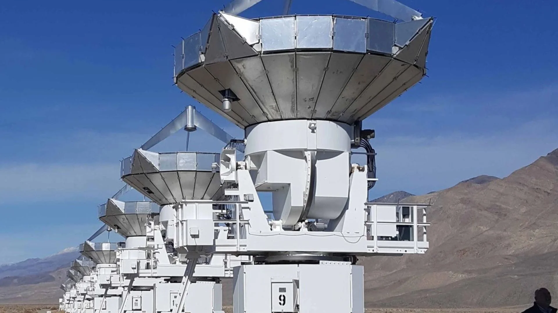
The SURe project will use the Arizona Array, a collection of radio antennas. Some antennas are mobile while others are installed at permanent locations. They form a network capable of collecting detailed satellite observations.
The antennas vary significantly in size. Some are about two meters in diameter, while the largest reach 12 meters. By working together, they can achieve results that would normally require a much larger telescope.
The system relies on a technique called very long baseline interferometry. This method combines signals from widely separated antennas. Researchers then process the collected data to create highly detailed images.
A simple way to understand the process is to imagine several cameras taking pictures of the same object from different locations. Computers combine the information from each viewpoint. The final result reveals details that a single camera might miss.
Astronomers have used this technique for years to study distant objects in the universe. It played an important role in imaging the event horizon of a supermassive black hole. The SURe project adapts the same concept for satellites orbiting much closer to Earth.
WATCH ALSO: Chinese company’s humanoid robot dodges arrow with side flip
Researchers will compare radio signals received by each antenna. Advanced software will correct timing and location-related differences. These adjustments allow the system to reconstruct images showing a satellite’s shape, orientation, and surface characteristics.
Buell Jannuzi, director of Steward Observatory and head of the Department of Astronomy, said the approach effectively creates a giant virtual telescope. The combined observations provide much greater resolution than a single antenna could achieve. This allows researchers to see more details about objects in orbit.
Another advantage of the system is its ability to operate under challenging conditions. Traditional optical telescopes depend heavily on clear skies and daylight conditions. The new millimeter-wave imaging approach works day and night and remains effective even in poor weather.
Walker said the combination of interferometry, target illumination, and near-field correction techniques offers significant advantages. These tools improve the ability to detect and monitor satellites in multiple orbital regions. The result is a more complete picture of activity in space.
The Space Force funded SURe through its Space Strategic Technology Institute 4 program. The program aims to move academic research into real-world applications. It also promotes collaboration among universities, government agencies, and private industry.
Several partners are contributing to the effort. Academic collaborators include the University of Massachusetts Lowell and the University of Virginia. Industry partners include FreeFall Aerospace Inc., Rincon Research Corp., DA2 Ventures, and Virginia Diodes.
University officials say the institution is particularly well-suited to lead the project. Its astronomy programs rank among the strongest in the world. The university also has extensive experience managing large-scale space science projects.
Walker previously led NASA’s GUSTO mission, a balloon-borne observatory that spent 57 days above Antarctica. The mission collected data about gas and dust between stars. Those observations help scientists understand how stars and galaxies form.
According to university officials, SURe represents the first partnership between Steward Observatory and the US Space Force focused on applying astronomy expertise to satellite monitoring.
The project also brings new research funding into Arizona’s growing space science sector. University leaders estimate that space science activities generate more than $560 million in annual economic impact for the state.
READ ALSO: NASA Trials Innovative Supersonic Parachute Delivery Technology
As satellite traffic continues to increase worldwide, accurate monitoring systems are becoming more important for both civilian and military operations. The new imaging network aims to provide clearer views of objects in orbit and strengthen awareness across the space environment.
Over the next three years, researchers hope the project will develop new tools that improve the safety, security, and long-term sustainability of space activities.