A research team at the OTH Regensburg is studying how advanced data collection and artificial intelligence can improve road safety.
The project focuses on cyclists and pedestrians, who are often described as vulnerable road users because they have little protection in traffic accidents. Researchers believe better data can help cities make more informed transport decisions.
Many cities already have extensive information about vehicle traffic. However, similar data for people walking or cycling is often limited. This makes it harder for planners to understand where safety problems occur and how to address them effectively.
The research is led by Simone Weikl. Her team is developing new ways to collect mobility data that capture the movement and behavior of cyclists and pedestrians in real-world conditions. The goal is to build a more complete picture of how different road users interact.
Mapping Urban Traffic Risks
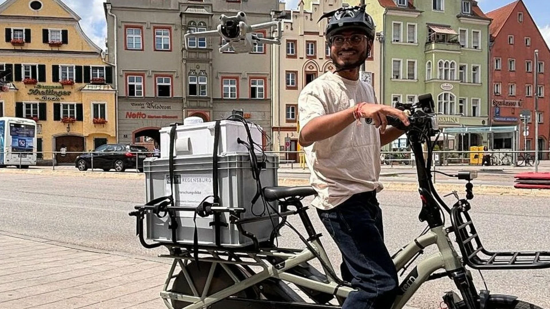
The team is currently examining ten junctions across the German city of Regensburg. Researchers use a specially built sensor bike while a video drone records traffic activity from above. This approach allows them to gather information from two viewpoints simultaneously.
As a student rides the sensor bike through traffic, onboard sensors record movement and environmental data. The drone captures a wider view of the surrounding traffic conditions. Together, the systems create a detailed record of what happens at busy intersections.
Artificial intelligence then analyzes the collected footage and sensor data. The technology identifies and classifies road users, including cars, bicycles, pedestrians, and e-scooters. This automated process enables researchers to analyze large amounts of data more efficiently.
The data helps create detailed movement profiles for every road user. Researchers can calculate speeds, acceleration rates, distances between vehicles, and other important safety indicators. These measurements reveal where near-misses and other risky interactions regularly occur.
The project highlights how AI can support transport planning without replacing human expertise. According to the research team, specialists are still needed to interpret the results and ensure conclusions are accurate. Human oversight remains an important part of the process.
From Research to Real-World Transport Planning
The practical value of these technologies is already visible in another project in Regensburg. Students recently analyzed LIDAR data collected at the city’s central bus station as part of the Real-World Laboratory for Urban Mobility initiative. LIDAR uses laser pulses to create highly detailed three-dimensional maps of an area.
The analysis showed where conflicts most often occurred between buses, cars, cyclists, and pedestrians. It also identified locations where vehicles were moving at unsafe speeds. These findings provided clear evidence of traffic risks that might otherwise go unnoticed.
READ ALSO: MIT model advances nuclear waste disposal, could be used to validate long-term safety
Based on the results, students prepared recommendations to improve safety around the transport hub. The proposals were submitted to the city council for consideration. This demonstrates how data-driven research can directly support local decision-making.
The work also reflects a broader trend in cities worldwide. Urban planners are increasingly using AI, sensors, drones, and smart mobility technologies to improve safety and traffic management. Better data enables authorities to make targeted investments rather than relying on assumptions.
The research team will share more details during the “Women in Data Science Regensburg” event on June 18 at Jahnstadion in Regensburg.
The presentation will explore how modern mobility data and artificial intelligence can help create safer, more efficient, and more livable cities. As urban areas continue to grow, projects like this are expected to play an increasingly important role in shaping the future of transportation.