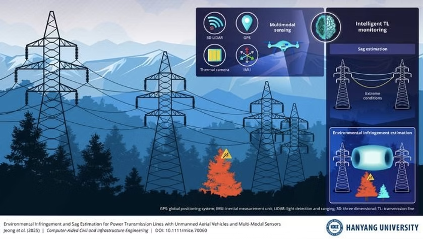
Researchers from Hanyang University have created a novel unmanned aerial vehicle (UAV) technology that simultaneously assesses transmission line sag and environmental infringement using multimodal data from 3D LiDAR, GPS, IMU, and thermal cameras.
Led by Professor Ki-Yong Oh, the system achieves unprecedented predictive capability by linking thermal measurements to sag-tension relationships, enabling infrastructure risk assessment under extreme conditions.
What if we could predict exactly where and when a transmission line might dangerously sag toward trees or structures—before contact ever occurs? This is no longer theoretical, thanks to groundbreaking research from South Korea that could transform how we monitor critical energy infrastructure across challenging landscapes.
A team from Hanyang University has developed the first comprehensive aerial monitoring system that simultaneously evaluates both current safety violations and future risks to transmission lines.
READ ALSO: https://www.modernmechanics24.com/post/china-hypersonic-mach7-mass-production
The research, led by Professor Ki-Yong Oh, Associate Professor of Mechanical Engineering at Hanyang University, and PhD candidate Munsu Jeon, represents a significant leap beyond traditional inspection methods that typically address only one aspect of transmission line safety at a time.
The innovation comes at a critical time. Power transmission lines span increasingly diverse and challenging environments, from dense forests to mountainous terrain, where environmental encroachment poses constant threats to grid reliability. Traditional inspection methods often require separate assessments for vegetation clearance and structural integrity, making comprehensive monitoring both time-consuming and expensive.
The Hanyang University approach solves this problem by integrating multiple sensing technologies onto a single unmanned aerial vehicle platform. The system uses 3D LiDAR, GPS, and IMU data to reconstruct precise geometric profiles of transmission lines, while thermal imaging captures conductor temperatures that influence line sag. This multimodal approach creates a dynamic understanding of transmission line behavior rather than just a static snapshot.
WATCH ALSO: https://www.modernmechanics24.com/post/ai-robot-picks-strawberries-fast
According to the research published in Computer-Aided Civil and Infrastructure Engineering, the true breakthrough lies in the predictive capability. By linking measured conductor temperature with sag–tension relationships, the technology can forecast how transmission lines would deform under extreme thermal conditions like heat waves or heavy loading. This means utility operators can identify potential future infringement scenarios before they materialize.
“Our technology can be used in aerial inspection and maintenance planning for overhead transmission corridors in operation,” explained Professor Oh. “By assessing sag and environmental infringement together across the full span, this approach supports routine monitoring in areas where vegetation growth, uneven terrain, or nearby structures increase the risk of contact with transmission lines.”
The environmental infringement assessment works by comparing the estimated sag profile with spatial distribution of surrounding objects. The system establishes an infringement zone with required clearance and uncertainty margins, then quantifies infringement by identifying environmental point cloud data within this zone. This generates monitoring indicators like intrusion depth, point density, and affected length to support automated monitoring and prioritized vegetation management.
READ ALSO: https://www.modernmechanics24.com/post/china-shenzhou-22-first-emergency-space-launch
For infrastructure managers, the practical applications are substantial. The technology enables inspectors to identify spans where lines are likely to approach nearby objects and take preventive action before interference occurs. It also helps prioritize vegetation removal, address emerging clearance issues, and reinforce vulnerable sections under higher temperature or loading scenarios.
Perhaps most significantly, the predictive insight enables more selective planning of seasonal inspections during periods of elevated risk. In remote, forested, or obstructed corridor segments where field access is difficult, inspectors can reduce the need for climbing, on-foot surveys, or repeated site visits by relying on comprehensive aerial data.
The research team emphasizes that their approach represents more than just improved measurement—it establishes a new framework for infrastructure monitoring. As Munsu Jeon noted, “As this type of monitoring becomes more common, similar principles could be applied to other infrastructure where on-site inspection is difficult or risky.”
WATCH ALSO: https://www.modernmechanics24.com/post/china-byd-ev-withstands-lightning-strikes
The timing is particularly relevant given increasing climate volatility. “This transition is also becoming more important as rapid weather shifts and unpredictable operating conditions make it difficult to rely on scheduled or in-person inspections,” Jeon added. “Automated monitoring would make it possible to detect emerging risks without waiting for visible damage or dispatching inspectors after conditions deteriorate.”
Published online on September 1, 2025, and in the journal on October 20, 2025, this research demonstrates how integrating existing sensing technologies with sophisticated analysis can create transformative solutions for critical infrastructure management. The Hanyang University system moves infrastructure monitoring from reactive problem-solving to proactive risk prevention, potentially saving millions in outage costs while improving grid resilience against climate challenges.
READ ALSO: https://www.modernmechanics24.com/post/tokamak-energy-demo4-fusion-magnetic-field-record